Why a Construction Survey Matters Before Building Near Retention Ponds
A construction survey is the first thing a developer should order before breaking ground near a retention pond. Most projects that run into legal or permit problems near ponds don’t fail because of bad design. They fail because someone started building without confirmed data on where the pond ends, what easements run along its edge, and what the drainage authority controls.
Retention ponds look simple. They’re just water. The complications are invisible until they show up in a stop-work order.
What a Retention Pond Actually Controls on a Site
A retention pond doesn’t just hold water. It’s a stormwater facility, and it almost always comes with recorded legal interests attached to the land around it.
Most ponds in planned developments sit inside a drainage easement. That easement gives a homeowners association, a local municipality, or a water management district the right to access and maintain the pond and its surrounding buffer. The structure you’re planning may sit right on top of that easement and you won’t know it without survey data.
County and water management district rules add another layer. Many areas require a minimum setback between any structure and the top of a pond’s bank. That setback gets measured from a specific point. That point has to be confirmed by survey. Estimates don’t satisfy permit reviewers.
If you’re building near a retention pond and you haven’t ordered a construction survey, you don’t know your true buildable area. You’re working with guesses.
What the Survey Confirms Before Design Is Final
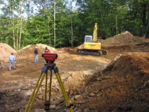
A construction survey near a retention pond does things no site visit can replace.
First, it locates the recorded easement boundaries on the ground. The easement is a legal document with bearings and distances. A surveyor turns those calls into physical stakes. Once you know where the easement line falls, you know where your building footprint can and can’t go.
Second, it confirms the pond’s top-of-bank location. This is the point most setback rules reference. The top of bank isn’t always at the water’s edge. After rain cycles and maintenance grading, the physical bank can shift from what older surveys show. A current survey reflects current conditions.
Third, it gives the civil engineer accurate data for the site plan. Grading, drainage connections, and impervious surface calculations all depend on knowing exactly where the pond sits. If those numbers are off by even a few feet, the stormwater design may not work as approved.
The Permit Problem That Comes Without Survey Data
Permit reviewers for sites near retention ponds check setback compliance on submitted plans. They compare proposed structure locations against recorded easement lines and required buffers. If that information is wrong, the permit gets rejected.
Resubmitting after a rejection isn’t just a paperwork delay. It pushes the project schedule, sometimes by weeks. If the design has to change to fix a setback error, consultants have to revise drawings and engineers have to update their calculations. The whole approval cycle starts over.
That sequence costs real money. The survey that would have caught the problem costs far less than one resubmission cycle.
There’s also a construction phase risk. Some developers get through permitting with plans that are close but not precise. When a surveyor sets the building corners in the field, the stakes sometimes fall inside the easement area. At that point, you’re looking at a stop-work order, regrading costs, and a conversation with the easement holder. Those conversations take time and money to resolve.
How Survey Data Protects the Project Schedule
Ordering the construction survey early gives the project team time to act on what the data shows.
If the easement line falls closer to the planned footprint than expected, the architect can shift the building placement before plans go to the engineer. If the top-of-bank measurement changes the required setback, the site plan can be revised before it goes to the permit office.
Survey data should go to the civil engineer before the stormwater report gets drafted. Stormwater calculations for sites near retention ponds depend on accurate pond geometry and easement boundaries. Getting those numbers late forces revisions at the worst possible time.
The sequence that protects the schedule is simple: survey first, design second, permits third. Any other order creates the risk of paid redesign work.
Frequently Asked Questions
What does a construction survey show around a retention pond?
A construction survey locates recorded easement boundaries on the ground, confirms the top-of-bank position, and gives the project team accurate data for the site plan and stormwater calculations. It shows exactly where the buildable area ends and where the pond’s protected buffer begins.
Is a construction survey needed before building near a retention pond?
Most counties and water management districts require setback compliance from the top of a retention pond’s bank. Permit reviewers check this against survey data on submitted plans. Developers who submit without verified survey data risk permit rejection or stop-work orders when construction begins.
What is a drainage easement around a retention pond?
A drainage easement is a recorded legal interest that gives a water management district, municipality, or homeowners association the right to access and maintain the pond and a buffer around it. Structures generally can’t be built inside that easement without approval from the easement holder.
When should a construction survey be ordered for a site near a pond?
The survey should be ordered before the civil engineer finalizes the site plan. Stormwater calculations, grading design, and structure placement all depend on accurate pond geometry and easement data. Ordering the survey after design work has started often forces paid revisions.
What is the difference between the water edge and the top of bank?
The water edge is the visible waterline at any given time. The top of bank is the edge of the pond’s containment structure above the normal water level. Most setback rules measure from the top of bank, not the water edge. The survey must confirm that specific point.
For a free land surveying quote, call us at (954) 519-7803 or send us a message by going here.