
Aerial Survey Drones for Tracking Multi-Phase Construction Without Slowing Crews
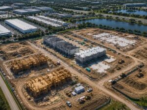
A multi-phase development brings a new problem every few months. You have to prove that phase one is done before phase two crews move in. An aerial survey run by drone gives developers a clean, dated record of each phase. Nobody has to stop working for it. For projects in Miramar, where several building pads or unit groups often move forward on staggered schedules, this kind of proof keeps the whole project on track.
One Site, Several Timelines
Tracking a single building is one problem. Tracking three or four phases moving at different speeds is another.
Phase one might be framing. Phase two might still be doing site work. Phase three may not have broken ground yet. Each phase needs its own progress record. But the whole site still needs to be understood as one connected picture.
Ground surveys struggle with this. A crew walking one phase does not easily capture how that phase relates to the others nearby. An aerial survey covers the entire site in one flight. It shows every phase at once, no matter what stage each one is in.
Putting Phases Side by Side
One of the clearest benefits of aerial tracking is being able to compare phases directly. This works best when every phase gets tracked the same way.
Same Data, Different Phases
When each phase gets flown using the same pattern and the same report format, comparing them becomes simple. A project manager can look at phase one’s week-twelve progress next to phase two’s week-twelve progress. That comparison shows exactly how the timelines line up. It also shows where one phase has fallen behind.
Catching Small Delays Before They Grow
Multi-phase projects often slip in small ways. A week here. A few days there. On their own, these delays seem minor. Over months, they add up fast.
Aerial data captured on a steady schedule makes that drift visible early. It shows up in the weekly numbers, not as a surprise three months later during a lender review.
Managing the Handoff Between Phases
One of the trickiest parts of multi-phase work happens at the handoff point. This is where one phase wraps up and the next phase starts using the same shared roads, laydown areas, or utility corridors.
Proof of Condition Before the Next Crew Moves In
Before phase two crews move into a shared area, a flight over phase one gives a clear record of what condition that area was in. This protects both contractors if a dispute comes up later. Maybe there’s a disagreement about damage. Maybe someone claims work was left unfinished. Either way, the flight data settles the question.
Watching Shared Roads, Ponds, and Utility Lines
Multi-phase sites often share roads, retention ponds, or utility trunks built during an early phase. Aerial survey data shows exactly how those shared elements hold up as later phases add more traffic and construction load nearby. If a shared road starts cracking under new construction traffic, the flight data will show when that started.
Checking That Phases Line Up on Grade
Different phases sometimes need to tie into the same overall grading plan, even though crews build them months apart. Lidar mapping data collected during each flight lets engineers confirm that phase two’s grading actually matches phase one’s finished elevations. This beats simply trusting that the plans lined up correctly on paper.
This matters most where two phases meet at a shared road or drainage path. A small elevation mismatch between phases can cause water to pool right at the connection point. That kind of problem is much cheaper to catch through survey data than to discover after paving is already done.
Building a Flight Plan That Bends With the Project
A useful flight schedule for multi-phase work needs to flex with each phase’s pace. It should not follow one fixed calendar for the whole site.
- Fly the entire site on a baseline schedule, even phases that have not started yet. This creates a record of pre-construction conditions.
- Fly more often over whichever phase is in active earthwork or framing.
- Fly right before any phase handoff, so conditions at the transition point get documented.
- Keep one running comparison log so every phase’s progress data lives in the same place. Do not scatter it across separate reports.
- Share flight data with all active contractors, not just the crew working on one phase. This helps everyone understand how the phases connect.
Local Factors That Make This Matter More in Miramar
A few local details make multi-phase tracking especially useful on Miramar developments.
- Large master-planned sites in this area often stagger phases over a year or more. Consistent, comparable data across time is more valuable here than a single snapshot.
- Shared retention ponds and drainage systems are common on multi-phase sites in this area. Tracking how later phases affect them matters for stormwater compliance.
- South Florida’s rainy season can push phases out of sync with the original schedule. Aerial data helps document exactly when and where that happened.
Setting Up Multi-Phase Tracking the Right Way
Before the first flight goes up, a few decisions make the whole process run smoother.
- Set one flight altitude and flight path for the entire site, so every phase gets tracked the same way.
- Decide upfront how often each phase needs a flight, based on its current stage of work.
- Agree on where flight data gets stored and who can access it. Multiple contractors and phases may need to reference the same records.
- Build phase handoff flights into the schedule from day one. Do not treat them as an afterthought once a problem comes up.
Frequently Asked Questions
How is tracking a multi-phase project different from tracking a single building?
Tracking a multi-phase project involves monitoring several construction areas that may be at different stages while using a consistent reporting format. This allows developers to compare progress across the entire project. A single-building project typically follows one construction schedule and a single set of milestones.
Can aerial survey data help resolve disputes between contractors working on different phases?
Yes. Aerial survey data creates a dated visual record of site conditions before and after work is completed. This documentation can help clarify responsibilities and resolve disputes involving shared work areas, project handoffs, or construction progress.
How often should each phase be surveyed on a multi-phase project?
The survey schedule should reflect the level of activity in each phase. Weekly flights are common during active grading, earthwork, or structural construction, while areas awaiting future development may only require periodic surveys to establish baseline conditions.
Does LiDAR mapping help when multiple phases connect to the same grading plan?
Yes. LiDAR mapping provides accurate elevation data that allows engineers to verify grade transitions between project phases. This helps maintain consistent drainage patterns and reduces the risk of elevation conflicts where separate phases meet.
Should contractors working on different phases have access to the same flight data?
In many cases, sharing aerial survey data improves coordination across the project. Access to current site information helps contractors understand how their work connects to adjacent phases, particularly near shared roads, stormwater facilities, and utility corridors.
For a free land surveying quote, call us at (954) 519-7803 or send us a message by going here.
Posted in land surveying, land surveyor | Tagged LiDAR Mapping