How Drone LiDAR Mapping Helps Verify Low-Lying Lots Before Development
Drone LiDAR mapping gives developers a precise picture of how low a lot sits before a single permit gets filed. On flat terrain, a few inches of elevation difference can mean the difference between a buildable lot and one that floods twice a year. LiDAR captures those inches. Standard surveys often don’t.
If you’re looking at a low-lying parcel and trying to figure out whether it can support a residential or commercial project, this is what you need to know about how drone LiDAR works and what it tells you that other methods miss.
Why Flat Lots Are Harder to Evaluate Than They Look
Low-lying land looks simple. It’s flat. There’s nothing complicated about a flat piece of ground.
That assumption trips up a lot of developers.
Flat land doesn’t drain evenly. Small dips collect water. Slight rises create barriers. A parcel that looks level from the street can hold standing water for days after rain. None of that is visible during a site walk, and none of it shows up clearly on a conventional boundary survey.
The problem is that traditional surveys measure property lines and corners. They’re not designed to capture surface drainage patterns or show where water pools. A boundary survey tells you where the lot ends. It doesn’t tell you what happens to rainwater on that lot.
That gap is where drone LiDAR comes in.
What Drone LiDAR Actually Measures
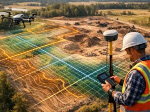
LiDAR stands for Light Detection and Ranging. A drone-mounted LiDAR system fires laser pulses at the ground and measures how long each pulse takes to return. The system collects millions of those measurements in a single flight. The result is a dense point cloud that shows the exact shape of the ground surface.
The accuracy is tight. Quality drone LiDAR systems deliver vertical accuracy within 5 to 10 centimeters under standard conditions. On low-lying land where 6 inches of elevation matters for drainage design, that precision changes what’s possible in pre-development analysis.
The drone covers the full parcel in a fraction of the time it would take a ground crew to collect comparable data manually. On a 5-acre lot, a drone LiDAR flight can collect enough data for a full digital elevation model in under two hours.
How the Data Gets Used in Low-Lying Lot Evaluation
Raw LiDAR data becomes useful after it’s processed into deliverables a civil engineer or site planner can work with. The most common outputs for pre-development evaluation are:
- Digital Elevation Models (DEMs) that show the terrain as a continuous surface with accurate elevation values
- Contour maps at 0.5-foot or 1-foot intervals that reveal drainage patterns invisible to the eye
- Slope analysis maps that show which areas shed water and which areas collect it
- Inundation modeling layers that show how far water spreads at different rainfall levels
A developer looking at a low-lying parcel can use those outputs to answer the questions that matter before purchase or permitting: Where does water go? How much fill is needed? What parts of the lot are buildable as-is and what parts need grading?
Those aren’t questions a site visit answers. LiDAR data does.
LiDAR and FEMA Base Flood Elevation Compliance
Low-lying lots in areas with FEMA flood maps carry an extra layer of complexity. The Base Flood Elevation (BFE) on a FEMA Flood Insurance Rate Map tells you the elevation a structure must meet or exceed to comply with local floodplain ordinances. Getting that number wrong at the start of a project creates expensive problems later.
Drone LiDAR data can confirm how the existing ground surface relates to the BFE before you commit to a development plan. If the lot sits below BFE, you know how much fill is required to bring the finished floor elevation into compliance. If it sits at or above BFE in some areas but not others, you can design around those constraints from the start.
That information shapes everything from foundation design to grading plans to stormwater management. Getting it early saves money. Getting it late, after permits are filed and plans are approved, can require expensive redesigns.
What a Pre-Development LiDAR Report Should Include
A useful pre-development LiDAR report for a low-lying lot covers more than raw elevation data. Developers should expect the report to include:
- A full point cloud dataset in a standard format (LAS or LAZ) for use by engineers and planners
- A DEM with documented vertical accuracy and control point information
- Contour mapping at intervals appropriate for the project scale
- A written summary that identifies areas of concern: low spots, drainage barriers, and any areas that appear to fall below the applicable BFE
- Recommendations for follow-up, including whether an official Elevation Certificate is needed and whether a stormwater analysis is warranted
A report that delivers only raw data without interpretation puts the burden on the developer to figure out what it means. A complete report flags the issues and tells you what to do next.
Frequently Asked Questions
What Is Drone LiDAR Mapping?
Drone LiDAR mapping uses a laser sensor mounted on a drone to measure ground elevation across a parcel. The drone fires laser pulses at the ground and records how long each one takes to return. The data creates a three-dimensional picture of the terrain with accuracy tight enough to catch drainage problems invisible to the eye.
How Accurate Is Drone LiDAR for Lot Elevation Mapping?
Quality drone LiDAR systems achieve vertical accuracy between 5 and 10 centimeters under standard conditions. That level of precision is enough to identify drainage patterns, low spots, and elevation differences that affect development decisions on flat or low-lying parcels.
Can Drone LiDAR Replace an Elevation Certificate?
No. An Elevation Certificate is a FEMA-required document prepared by a licensed surveyor or engineer to certify finished floor elevations for flood insurance and permitting purposes. Drone LiDAR provides terrain data that helps you plan before construction. The Elevation Certificate documents the structure after it’s built. Both serve different functions.
How Long Does a Drone LiDAR Flight Take on a Development Parcel?
Flight time depends on parcel size and local airspace requirements. On a 5-acre parcel, the flight itself typically takes under two hours. Data processing and report preparation add additional time, typically one to three business days depending on the complexity of the analysis requested.
Why Does LiDAR Perform Better Than Traditional Surveys on Flat Terrain?
Traditional ground surveys collect elevation at individual points. On flat land, spacing between those points can miss drainage features between measurements. LiDAR collects millions of points across the entire surface in a single pass, creating a continuous picture of the terrain at a density no ground crew can match in the same timeframe.
For a free land surveying quote, call us at (954) 519-7803 or send us a message by going here.