
Topographic Survey Explained: What Homeowners Need to Know
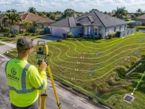 A topographic survey is a detailed map of your land that shows elevations, slopes, drainage patterns, and physical features like trees, utilities, and structures. In Miramar, it is required for most construction permits and is one of the most important tools for understanding your property’s flood risk before you build, renovate, or buy.
What Is a Topographic Survey?
A topographic survey is a land survey that measures the shape of your property in three dimensions. It tells you how high or low different parts of your land sit, which direction water flows, and what physical features are on the ground.
Most people know about boundary surveys, which show where your property lines are. A topographic survey goes further. It captures the full picture of your land, including its slopes, drainage patterns, trees, and any existing structures.
Surveyors and engineers use this data to plan buildings, design drainage systems, and prepare permit applications. According to the City of Miramar Building Department, a current signed and sealed survey is required for most new construction and major renovation permits. If you are buying, building, or renovating, this is a survey you will likely need.
Why It Matters in Miramar
Miramar sits in one of the flattest parts of Broward County. That might sound simple, but flat land creates real drainage problems. When rain falls here, the water has nowhere to go quickly. It spreads, pools, and drains slowly.
According to the Florida Department of Transportation Drainage Design Guide, a change of just one foot in elevation per 100 feet of land determines whether stormwater moves or stands still in flat South Florida terrain. On a typical Miramar lot, that small difference can mean a dry backyard or one that floods after every heavy rain.
There is also a more urgent reason this matters right now. In 2024, FEMA updated its flood maps for Broward County and added more than 25,000 Miramar properties to its official flood zones. Many homeowners who had never worried about flooding suddenly found themselves inside a designated flood hazard area.
Those map changes were based on updated topographic data showing ground elevations in greater detail. If your property was reclassified, a topographic survey gives you the data you need to understand your actual elevation. It also gives you what you need to challenge your flood zone status through a FEMA Letter of Map Amendment (LOMA).
What Does a Topographic Survey Include?
A completed topo survey gives you a detailed site map that shows the following:
Contour Lines and Elevations. These lines connect points at the same elevation. They show which parts of your land sit higher or lower and how steep or gentle the slopes are. In South Florida, contour lines are usually drawn at 0.5-foot or 1-foot intervals.
Drainage Flow Direction. The survey shows where water naturally moves across your lot. Engineers use this to design drainage systems that work with your land rather than against it.
Structures and Improvements. Everything built on your property is recorded, including your home, driveway, pool, fence, retaining walls, and outbuildings, along with their elevations.
Trees and Vegetation. Significant trees are marked on the map. This is important for permit applications and construction setback rules in Broward County.
Utilities. Water lines, sewer pipes, drainage swales, and electrical lines that are visible or documented are noted on the survey.
Flood Elevation Reference. In Miramar, topo surveys often include a reference to the FEMA Base Flood Elevation (BFE). This shows how your land compares to the official flood threshold for your area.
How Is It Done?
Here is a simple breakdown of how the process works:
Step 1: Research The surveyor looks at property records, prior surveys, plat maps, and utility documents before visiting your site.
Step 2: Field Work Using GPS, robotic total stations, or drones with LiDAR sensors, the surveyor collects hundreds of elevation points across your land.
Step 3: Processing The field data is turned into a Digital Elevation Model and a contour map using CAD software.
Step 4: Final Drawing You get a signed and sealed drawing with contour lines, physical features, and key elevations.
Step 5: Submission The finished survey goes to your engineer, architect, or the Miramar Building Department.
When Do You Need One?
Order a topographic survey before or during any of these:
- Building a new home. The Miramar Building Department requires it for most new construction permits.
- Major renovations or additions. Any project that changes grading or drainage patterns needs updated topo data.
- Installing a pool or driveway. Broward County and the South Broward Drainage District may require drainage documentation.
- Challenging a FEMA flood zone designation. You need elevation data to file a LOMA or LOMR-F with FEMA.
- Buying a vacant lot. Finding out about drainage issues before you close saves you from costly problems later.
- Applying for a stormwater permit. The South Florida Water Management District (SFWMD) requires this for new development projects.
How Much Does It Cost?
A topographic survey typically costs between $800 and $3,500 for a standard residential lot, based on 2026 pricing data. Broward County properties run 15 to 25 percent above the national average because of flood zone requirements and the density of local development.
The main factors that affect your price:
- Lot size. Bigger properties take more time in the field.
- Vegetation. Overgrown or wooded lots cost more because of clearing.
- Flood zone status. AE or VE zone properties need extra elevation documentation.
- Turnaround time. Standard delivery is 5 to 10 business days. Rush service can add 50 to 100 percent to your cost.
- Bundling. Ordering a boundary and topo survey together in one visit saves 20 to 30 percent.
Always get at least three quotes and check your surveyor’s license through the Florida Department of Business and Professional Regulation (DBPR).
Frequently Asked Questions
Is a topographic survey required for a building permit?
Yes. The City of Miramar Building Department requires a current, signed, and sealed survey for most new construction and major addition permits. If your project changes drainage or site grading, topographic data is a required part of the package, not something optional.
Can it help lower my flood insurance?
Yes. Topo data is used to prepare an Elevation Certificate, which compares your building’s finished floor elevation to the FEMA Base Flood Elevation. If your home sits above the BFE, your flood insurance premiums through the National Flood Insurance Program can drop significantly. Even a one-foot difference can save you hundreds or thousands of dollars per year.
Can I use Google Maps instead?
No. Satellite imagery does not have the accuracy needed for permits, engineering, or FEMA applications. The City of Miramar and Broward County both require surveys that are signed and sealed by a licensed Professional Land Surveyor (PLS) registered in Florida.
How long does it take?
Most residential topo surveys in Broward County take 5 to 10 business days from the field visit to final delivery. Rush service is available but adds to the total cost.
What is the difference between a topographic and a boundary survey?
A boundary survey shows where your property lines are. A topographic survey maps the three-dimensional shape of your land, including elevations, slopes, and drainage. Many homeowners order both together to save 20 to 30 percent on the total cost.
For a free land surveying quote, call us at (954) 519-7803 or send us a message by going here.
Posted in land surveying, land surveyor |